Near Mine Exploration
Foran optimizes its investment in exploration through a disciplined approach to target generation and prioritization, integration of multidisciplinary data, and staged drilling campaigns so that learnings can be incorporated into subsequent targeting. Ongoing exploration is critical to identify future feed for the McIlvenna Bay processing facility.
Expansion of exploration activities into the rest of Foran’s extensive ground holdings will continue in 2022.
Several highly prospective targets have been identified throughout Foran’s land holdings.
Tesla
Proximity
Adjacent to and north of McIlvenna Bay deposit
Planned Work
Late 2021, drill to depth and lower an EM probe close to the target area
Characteristics
Ground EM anomaly, extends 1000m along a structure that separates magnetic gabbros in the east from volcanics to the west
Comments
The interpreted structural setting aligns with our understanding of the structural controls of mineralization for the McIlvenna Bay deposit
Volta
Proximity
1500m east of McIlvenna Bay deposit
Planned Work
2022, drill to depth and lower EM probe to better target follow up drilling
Characteristics
Numerous overlapping EM responses
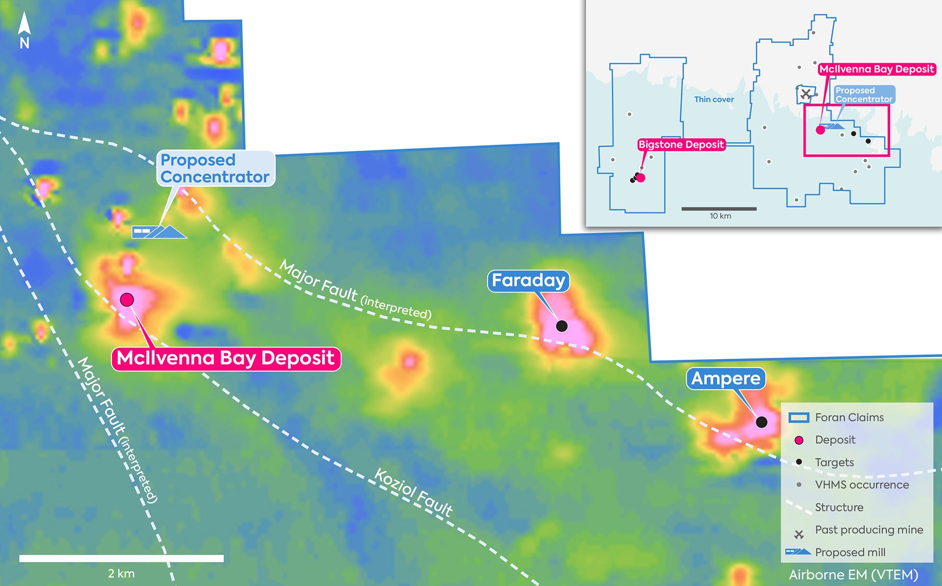
Faraday
Proximity
4km east of McIlvenna Bay deposit
Planned Work
Downhole EM surveys were completed in 2021. Modelling data, awaiting assay results.
Characteristics
Two holes drilled in 2021. Intersected sulphidic sediment/volcanic contact with evidence of pillow basalts.
Comments
Appears to be the right geologic environment for development and preservation of a VHMS system.
Ampere
Proximity
7km east of McIlvenna Bay deposit
Planned Work
Follow up on downhole EM surveys.
Characteristics
Similar target to Faraday. 2021 drilling based on modeled data from surface EM survey. Drilled two holes – first hole intersected up to 12% pyrite in a graphitic argillite above an interbedded package of volcanics and sediment. Second hole intersected weak mineralized BIF that may be contributing to surface anomaly.
Comments
Favourable geologic setting. Assess further work once assays are received.
Flinty
Proximity
6.5km south of McIlvenna Bay deposit
Planned Work
Both targets at Flinty will be tested in 2022.
Characteristics
Three historic drill holes intersected stockwork sulphides (4.6m @0.62% Cu, 0.55% Zn and 3.0m of 2.25% Zn). Downhole EM survey was completed. Surface EM survey done in early 2021, conductor modeled consistent with historic downhole EM. A second conductor was modeled from surface EM approximately 400 m south
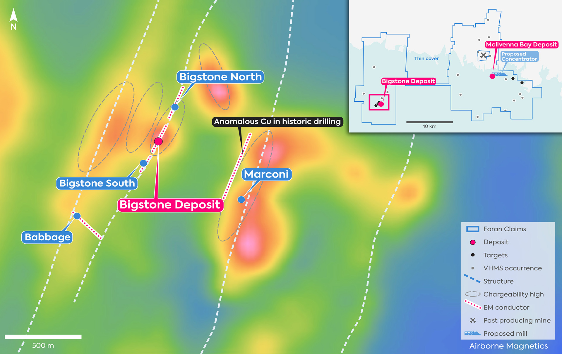
Marconi
Proximity
600m east of Bigstone deposit
Planned Work
Two holes were drilled in 2021. Downhole EM surveys planned for early 2022 to inform future drilling. Assay results are pending.
Characteristics
900m long trend consistently mineralized over 9 drill sections. Historic drilling intersected anomalous copper over approximately 800m strike length
Babbage
Proximity
600m south of Bigstone deposit
Planned Work
Additional surface EM survey work required.
Characteristics
Nearby historic hole intersected porphyry style quartz vein controlled Cu-Mo mineralization. Also denoted by a surface EM target. Downhole EM survey results were indeterminate.
Ada
Proximity
11km northwest of McIlvenna Bay deposit
Planned Work
Currently being formulated.
Characteristics
1.8km long VTEM and magnetic anomaly outside of the Phanerozoic cover. Massive sulphide has been intersected in limited historic drilling. Interpretation of magnetic data indicates Ada is in a similar structural position to McIlvenna Bay deposit.