McIlvenna Bay
Targeting Carbon Neutral Production
McIlvenna Bay is a carbon neutral copper development project, host to a significant and scalable resource located in Saskatchewan, Canada, which is one of the world’s premier mining jurisdictions.
McIlvenna Bay is the largest undeveloped VHMS deposit along the prolific Flin Flon Greenstone Belt.
With Probable Mineral Reserves of 25.7 Mt at 2.51% CuEq containing 697 million pounds of copper and 1.4 billion pounds of zinc included in a Mineral Resource of 39 million Indicated tonnes grading 2.04% CuEq for 1.0 billion pounds of copper and 1.9 billion pounds of zinc and 5 million Inferred tonnes grading 1.8% CuEq for 104 million pounds of copper and 282 million pounds of zinc.
The McIlvenna Bay Project is designed around a newly defined reserve accessed by new development and shares geologic characteristics similar to other major mines along the Flin Flon Greenstone Belt. Recent feasibility results outlined an initial phase 18 year mine life producing 65 Mlbs of copper equivalent at an average all-in sustaining cost (net of credits) of $0.90/lb. The McIlvenna Bay Project is levered to commodity prices. At spot prices as at Arpil 4, 2022 (copper US$4.81/lb), the initial phase project delivers a pre-tax NPV7% of C$1.1 billion and IRR of 54% (C$1.3B and 44% after-tax). The Deposit remains open and regional exploration continues to demonstrate the exciting potential to increase throughput and mine life.
Clean, Safer, and Efficient
The mine is being designed to take advantage of the latest technological advances as well as planning for future improvements, reducing our emissions and making the mine even safer and more efficient.
Key Stats
20,900
Hectare licence area.
85km
West of Creighton, Saskatchewan via provincial highway.
100%
Owned by Foran.
Grading at 2.04% Copper Equivalent:
1.20%
Copper
2.16%
Zinc
0.41g/t
Gold
14g/t
Silver
Contains:
1.03 billion lbs Cu
1.9 billion lbs Zn
510,000 oz Au
18.0 million oz Ag
Grading at 1.77% Copper Equivalent:
0.94%
Copper
2.56%
Zinc
0.27g/t
Gold
16g/t
Silver
Contains:
105 million lbs Cu
284 million lbs Zn
40,000 oz Au
2.6 million oz Ag
Reports
Location and Infrastructure
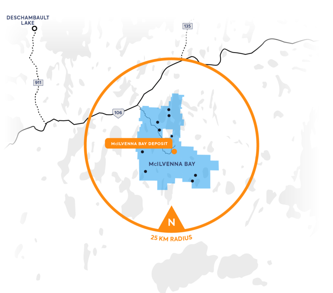
Foran’s 20,900 hectare McIlvenna Bay Property is located in east-central Saskatchewan, approximately 65 km west of Flin Flon, Manitoba (85 km by road).
The McIlvenna Bay deposit and Foran’s exploration camp are road-accessible, located 85 km west of Flin Flon via Provincial Highway 106 and 17 km south on the Hanson Lake all-weather gravel road. Power lines run the length of the Hanson Lake gravel road to the McIlvenna Bay deposit.
The mining town of Flin Flon (pop. 5,600), is the largest commercial/residential centre in the area and a railhead on the Hudson Bay railway. The Flin Flon airport has regular commercial air service to Winnipeg.

Ownership
Foran has a 100% interest in the McIlvenna Bay property, with some of the claims subject to a Net Tonnage Royalty of $0.75 per tonne of ore extracted, with Foran holding a right of first refusal if an offer to purchase the Net Tonnage Royalty is made.
Cameco Corporate and BHP collectively hold a 1% Net Smelter Return royalty interest on McIlvenna Bay, which can be repurchased at any time for $1 million.
Additional Info
The McIlvenna Bay deposit was discovered in early 1988 during a drill program by a Saskatchewan Mining Development Corporation (“SMDC”; subsequently Cameco Corporation) and Esso Minerals joint venture, following up on a Barringer/Questor Mark VI helicopter INPUT survey which delineated a 1.2 kilometre long anomaly south of Hanson Lake. In addition to its proximity to several VHMS deposits in the established Flin Flon mining camp, several VHMS occurrences were known in the immediate McIlvenna Bay area. These include the past-producing high-grade Hanson Lake Mine and the Balsam deposit, where past operators outlined an historic mineral resource*.
* The Balsam mineral resource is historic and the Company is not treating it as current; Foran has not done sufficient work to classify it as a current resource estimate. A program of drill hole re-surveying, re-logging and drill core QAQC is required to qualify the historic resource and identify areas for expansion through exploration drilling.
In 1991 Cameco suspended exploration of the McIlvenna Bay deposit, which remained dormant until optioned by Foran in 1998. Foran completed several additional drill programs between 1998 and 2000. Following a period of inactivity and the appointment of a new management team in late 2010 – early 2011, Foran completed several drill campaigns between early 2011 and 2014.
The following table summarizes diamond drilling at McIlvenna Bay from discovery of the deposit in 1988 to completion of the Winter 2013 Drill Program:
| YEAR | COMPANY | NUMBER OF HOLES | METERS DRILLED |
|---|---|---|---|
| 1988 | Cameco/Esso/TriGold | 26 | 7,702 |
| 1989 | Cameco/TriMin | 30 | 14,565 |
| 1990 | Cameco/Billiton | 13 | 7,869 |
| 1998 | Foran | 3 | 978 |
| 1999 | Foran | 62 | 28,993 |
| 2000 | Foran | 3 | 2,938 |
| 2007/08 | Foran | 7 | 6,525 |
| 20011 | Foran | 28 | 13,214 |
| 2012 | Foran | 15 | 3,825 |
| 2013 | Foran | 4 | 2,243 |
| Total | 191 | 88,681 |
Regional Geology
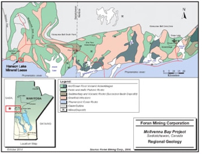
The McIlvenna Bay deposit is located on the western edge of the Paleoproterozoic Flin Flon Greenstone Belt (FFGB) which extends from north central Manitoba into northeastern Saskatchewan. The FFGB forms part of the Reindeer Zone, a subdivision of the Trans-Hudson Orogen, a continental-scale tectonic event which occurred approximately between 1.84 Ga and 1.80 Ga as a result of the collision between the Superior and Hearne Archean Cratons.
The Hanson Lake Block, the host terrain of the McIlvenna Bay deposit, is bound to the east by the Sturgeon-Weir Shear Zone and to the west by the Tabbernor Fault Zone. This supracrustal block extends to the south beneath flat lying cover of Ordovician sandstones of the Winnipeg Formation and dolomites of the Red River Formation. To the north, the block is bound by the Kisseynew Domain, a gneissic metasedimentary belt and the Attitti Complex.
In the Hanson Lake area, north of the Paleozoic unconformity, exposed Proterozoic rocks of the Hanson Lake Block are dominated by juvenile island arc, felsic to intermediate metavolcanic rocks, with subordinate amounts of mafic volcanics and sedimentary rocks. Oxide facies iron formations have been identified by diamond drilling and are readily identified in airborne magnetic data. The sequence has been intruded by various felsic intrusions, some of which are believed to be subvolcanic. Abundant diorite and gabbro plugs and dykes cut the sequence, as well as minor ultramafic intrusions. Supracrustal rocks in the Hanson Lake area are northerly trending, upright and east-facing.
Property Geology
Lacking outcrop in the area of the McIlvenna Bay deposit, the property geology has been interpreted from the drill core record with help from geophysical surveys.
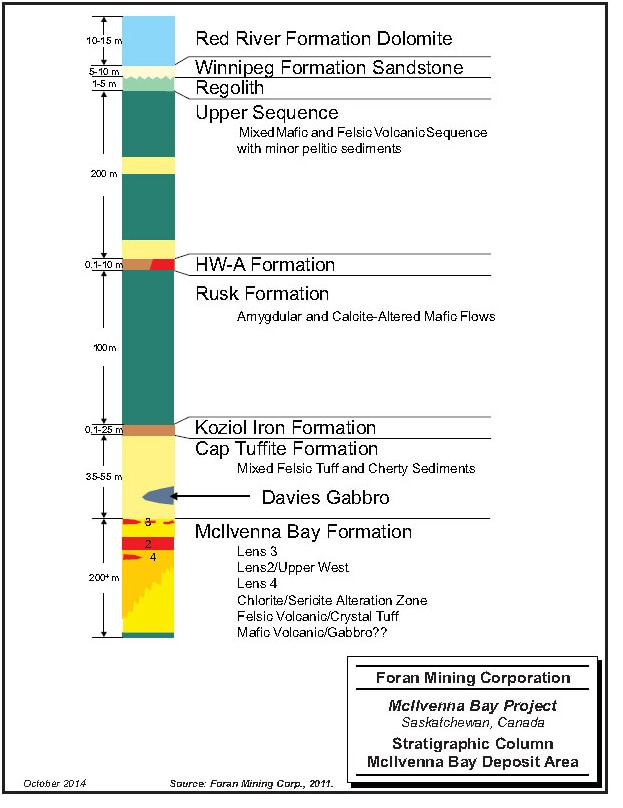
The stratigraphy of the deposit area, divided into six formations, has been defined over a 2 km strike length by a total of 191 drill holes. The lowest formation intersected by drilling both structurally and stratigraphically is the McIlvenna Bay Formation, which consists of variably altered felsic volcanic and volcaniclastic units. The formation is at least 200m thick (the limit of current drilling) and is the host to both the massive and semi-massive sulphide horizons and underlying stockwork zones that make up the McIlvenna Bay deposit. The McIlvenna Bay Formation is overlain to the north by the Cap Tuffite Formation, a sequence of intercalated felsic volcanics and cherty metasediments which ranges from 35-55m in true thickness and forms a cap to the sulphide deposits. Overlying the Cap Tuffite Formation is the Koziol Iron Formation, an oxide-facies iron formation up to 25m in true thickness which forms a long and distinctive marker horizon traceable for several kilometres along strike by drilling and geophysics. Topping the Koziol Iron Formation is the Rusk Formation, a thick package of carbonate altered mafic volcanics rocks, up to 100m in true thickness. The Rusk Formation is in turn overlain by the thin HW-A Formation, an exhalative oxide-sulphide facies iron formation that locally transitions laterally into pyrite-pyrrhotite-sphalerite bearing massive sulphide. This unit ranges from 1cm to about 5m in true thickness. Capping the HW-A Formation is a thick unsorted bimodal package of mafic and felsic volcanics, mafic intrusions, minor sediments and iron formations tentatively called the Upper Sequence. The stratigraphic package has been cut by several different intrusions, the most significant of which is the Davies Gabbro, a series of sill-like bodies which intrude the Cap Tuffite Formation. The basement geology is unconformably overlain by the flat lying to shallowly south-dipping Ordovician dolomites and sandstones of the Red River and Winnipeg Formations which have a combined total thickness between 20 and 30m.
Stratigraphy in the deposit area strikes between 275° and 295° and dips to the north at 65° to 70°, although in selected areas it dips vertically. The deposit has the same orientation as the stratigraphy and plunges at approximately 45° to the northwest. Rocks in the host stratigraphy are massive to strongly foliated, the intensity of which depends on the competency of each individual unit and the degree of alteration. Rocks are variably altered to sericite and chlorite throughout the deposit area and have been subjected to greenschist facies regional metamorphism.
Two phases of folding of the host stratigraphy have been observed in the drill core and are believed to correspond to the regional D2 and D3 deformational events. An early tight to isoclinal fold event (regional D2/F2) was responsible for the development of the dominant observed structural fabric, a foliation oriented at approximately 280°/65°, and resulted in the transposition of bedding into the plane of the foliation (making the foliation sub-parallel to stratigraphy). Isolated isoclinal fold hinges in iron formation units have been observed in several drill holes that have a plunge that is estimated to be approximately 45° to the west or west-north-west. This plunge is roughly parallel to the plunge of the deposit and indicates that the D2 deformational event was likely responsible for the current geometry of the deposit. A strong crenulation (regional D3/F3 event) of the foliation is developed in portions of the footwall alteration zone. The plunge of the crenulation is much flatter, usually less than 25° and trends either northwest or northeast.
McIlvenna Bay is a volcanogenic massive sulphide (VHMS) deposit, of a type commonly found in Canada in Precambrian through Mesozoic volcano-sedimentary greenstone belts occupying extensional arc environments such as a rifts or calderas. They are typified by synvolcanic accumulations of sulphide minerals in geological environments characterized by submarine volcanic rocks.
VHMS deposits are exhalative deposits, formed through the focused discharge of hot, metal-rich hydrothermal fluids. These deposits commonly occur in clusters which, when developed constitute localized mining districts or VHMS camps. A single deposit or mine may consist of several individual massive sulphide lenses and their underlying stockwork zones. It is thought that the stockwork zone represents the near-surface channel ways of a submarine hydrothermal system and the massive sulphide lens represents the accumulation of sulphides precipitated from the hydrothermal solutions, on or near the sea floor, in close proximity to the discharge vent.
The 2021 Resource Estimate includes several zones and two distinct styles of mineralization, typical of volcanic-hosted massive sulphide (“VHMS”) deposits:
- massive to semi-massive sulphide mineralization in the Main Lens and Lens 3
- stockwork-style sulphide mineralization in the Copper Stockwork Zone (“CSZ”) that directly underlies the Main Lens;
- two other small lenses of stockwork-style mineralization occur in the Deposit:
- the Stringer Zone, which is located between the Main Lens and Lens 3
- the Copper Stockwork Footwall Zone (“CSFWZ”) which occurs as a separate lens underneath the CSZ for approximately 150m of strike length which could represent a fault offset and repetition of the Main Lens and CSZ.
The Main Lens at McIlvenna Bay is a large massive to semi-massive sulphide horizon containing a metal zonation consisting of Cu-Au-rich material near the upper plunge line of the Deposit which transitions down dip into a more Zn-Ag-dominant massive sulphide. The Main Lens massive sulphide is a continuous mineralized horizon which varies from 0.1 to 18.0m in true thickness and averages 3.5m overall, with a strike length of 1,850m (Figure 5).
The CSZ is a zone of stockwork style copper-rich mineralization that directly underlies and is in contact with the massive sulphide and is interpreted to represent the feeder zone to the massive sulphide system. The CSZ varies from 0.3 to 26m in true thickness with an average thickness of 12.0m. The Main Lens massive sulphide and the underlying CSZ are generally in contact with one another throughout the Deposit, giving the bulk of the Deposit an average thickness of 15.5m overall. The Deposit plunges at approximately 45 degrees from surface for a down plunge length of approximately 2,000m (Figure 6).
Lens 3 sits approximately 10 to 30m in the hanging wall above the Main Lens and demonstrates the presence of stacked sulphide lenses in the Deposit. This lens has been traced intermittently along a strike length of 1,600m and plunges parallel to the underlying Main Lens and CSZ. The lens ranges in thickness from 0.1 to 8.0m and averages 2.0m in true thickness. The Stringer Zone is a narrow intermittent lens of stringer-style sulphide that occurs sporadically between the Main Lens and Lens 3 through the Deposit. The zone has a strike length of 850m and averages 4.5m in true thickness through the deposit.
The CSFWZ is a separate lens that underlies the CSZ and has been intersected in nine drill holes over approximately 150m of strike length in the up-dip, central part of the Deposit. The lens varies in thickness from 0.3 to 38m with an average thickness of 30m. The CSFWZ dominantly consists of stockwork style copper-rich mineralization similar to the CSZ, although in several holes, narrow massive sulphide was also intersected at the top of the interval. It is possible that the CSFWZ represents a fault offset and repetition of the Main Lens and CSZ, but further drilling is required to prove the relationship of this lens to the rest of the Deposit.
McIlvenna Bay 2021 Mineral Resource Estimate (US$60/t NSR cut-off) 1-6
| Zone | Tonnage (Mt) | NSR ($US) | Cu (%) | Zn (%) | Pb (%) | Au (g/t) | Ag (g/t) | CuEq (%) |
|---|---|---|---|---|---|---|---|---|
| INDICATED | ||||||||
| Main Lens Massive Sulphide | 10.8 | 199 | 1.01 | 6.17 | 0.41 | 0.53 | 27 | 3.13 |
| Lens 3 | 2.6 | 113 | 0.82 | 3.07 | 0.14 | 0.25 | 15 | 1.80 |
| Stringer Zone | 1.2 | 119 | 1.26 | 0.52 | 0.07 | 0.31 | 13 | 1.53 |
| Copper Stockwork Zone | 22.7 | 127 | 1.31 | 0.38 | 0.02 | 0.37 | 9 | 1.79 |
| Copper Stockwork Footwall Zone | 1.8 | 141 | 1.42 | 0.59 | 0.04 | 0.45 | 9 | 1.79 |
| TOTAL INDICATED | 39.1 | 146 | 1.20 | 2.16 | 0.14 | 0.41 | 14 | 2.04 |
| INFERRED | ||||||||
| Main Lens Massive Sulphide | 1.6 | 163 | 0.65 | 6.51 | 0.46 | 0.29 | 28 | 2.66 |
| Copper Stockwork Zone | 3.5 | 106 | 1.08 | 0.79 | 0.03 | 0.25 | 11 | 1.37 |
| TOTAL INFERRED | 5.0 | 123 | 0.94 | 2.56 | 0.17 | 0.27 | 16 | 1.77 |
1 Effective date September 6, 2021; CIM definitions were followed for Mineral Resources; CuEq = copper equivalent; NSR = Net Smelter Return. Totals may not add due to rounding.
2 The base case mineral resource is estimated based on 240 diamond drill holes and a NSR cut-off value of US$60/t. NSR value was calculated using Cu, Zn, Au, Ag and high-grade caps were applied as per the discussion in Estimation Methodology and Parameters below and include provisions for metallurgical recovery and estimates of current shipping terms and smelter rates for similar concentrates. Metal prices used are US$4.25/lb. Cu, US$1.35/lb. Zn, US$1,800/oz. Au, and US$25.00/oz. Ag, versus US$3.30/lb. Cu, US$1.25/lb. Zn, US$1,310/oz. Au and US$16.20/oz. Ag, used for the previous resource estimate in 2019. Specific gravity was interpolated for each block based on measurements taken from core specimens, with an average value of 3.59 for the main Massive Sulphide (“MS”) lens and 2.87 for the Copper Stockwork Zone (“CSZ”)
3 Mr. William J. Lewis, P.Geo., of Micon, has reviewed and verified this mineral resource estimate. Mr. Lewis is independent of Foran and is a “Qualified Person” within the meaning of NI 43-101.
4 Mineral resources which are not mineral reserves do not have demonstrated economic viability. The estimate of mineral resources may be materially affected by environmental, permitting, legal, marketing or other issues. Due to the uncertainty which may attach to inferred mineral resources, it cannot be assumed that all or any part of an inferred mineral resource will be upgraded to an indicated or measured mineral resource as a result of continued exploration.
5 CuEq values were calculated from the NSR values for each zone using both concentrate and recovery curves that were developed during Pre-Feasibility level metallurgical studies.
6 A sensitivity table is provided in Figure 2 below which demonstrates the variation in tonnage and grade for the main zones MS and CSZ at different NSR cut-offs.
The 2021 Resource Estimate builds upon and supersedes the previous NI 43-101 mineral resource estimate for the Deposit which was announced by the Company on May 23, 2019 (the “2019 Resource Estimate”). The 2021 Resource Estimate uses long term metal price projections of US$4.25/lb. Cu, US$1.35/lb. Zn, US$1,800/oz. Au, and US$25.00/oz. Ag. The base case uses a US$60/t NSR cut-off using provisions for metallurgical recoveries, smelter payables, refining costs, freight and applicable royalties.
Contained Metal
There has been substantial growth in the McIlvenna Bay resource since the 2019 Resource Estimate was issued including a 74% increase in contained Cu, 21% in contained Zn, 47% increase in contained Ag and 58% increase in contained Au. See Table 2 below outlining the contained metal in the 2021 Resource Estimate.
2021 Resource Estimate – Contained Metal (US$60/t NSR cut-off) 1, 2
2021
| Zone | Resource Classification | Cu Mlbs | Zn Mlbs | Ag Moz | Au Moz | Pb3 Mlbs |
|---|---|---|---|---|---|---|
| Main Lens Massive Sulphide | Indicated Inferred | 238 22 | 1,462 224 | 9.2 1.4 | 0.18 0.01 | 98 16 |
| Lens 3 | Indicated | 47 | 174 | 1.2 | 0.02 | 8 |
| Stringer Zone | Indicated | 33 | 14 | 0.5 | 0.01 | 2 |
| Copper Stockwork Zone | Indicated Inferred | 659 83 | 190 60 | 6.7 1.2 | 0.27 0.03 | 10 3 |
| Copper Stockwork Footwall Zone | Indicated | 56 | 23 | 0.5 | 0.03 | 2 |
| TOTAL CONTAINED METAL | Indicated Inferred | 1,033 105 | 1,863 284 | 18.1 2.6 | 0.51 0.04 | 119 19 |
1 Totals may not add due to rounding
2 See footnotes 1-5 for Table 1
3 Pb is not recoverable, is listed for informative purposes only
Scoping level metallurgical test work was conducted on composite samples from Zone 2 (L2MS), the Upper West Zone (UW-MS) and the Copper Stockwork Zone (CSZ) in 2011. Samples were found to be amenable to conventional grinding and floatation. This work demonstrated the potential to produce saleable high grade copper and zinc concentrates at McIlvenna Bay.
Due to the differences in the mineralogy of the zones, a variety of concentrates were produced by the testwork as detailed in the table below. The copper-rich CSZ produces a high grade copper concentrate (Cu Con#1), the UWZ has a mixed mineralogy and produces both a copper concentrate (Cu Con#2) as well as a zinc concentrate (Zn Con#2) and Zone 2 produces a good zinc concentrate (Zn Con#1) along with a ‘bulk concentrate’ which contains the other minor elements (Cu-Pb) included in the lens.
McIlvenna Bay Metallurgical Results
| Zone | Copper Concentrates | Zinc Concentrates |
|---|---|---|
| Copper Stockwork Zone Composite Head Grade: 1.45% Cu, 0.34 g/t Au, 8 g/t Ag | Cu Conc. #1 Grade: 29% Cu, 6.4g/t Au, 126g/t Ag Recoveries: 94% Cu, 85% Au, 77% Ag | N/A |
| Main Lens: Upper West Zone Composite Head Grade: 3.97% Zn, 1.61% Cu, 0.55 g/t Au, 25 g/t Ag | Cu Conc. #2 Grade: 24% Cu, 6.5g/t Au, 216g/t Ag Recoveries: 84% Cu, 60% Au, 50% Ag | Zn Conc. #2 Grade: 54% Zn Recovery: 76% Zn |
| Main Lens: Zone 2 Composite Head Grade: 7.25% Zn, 0.30% Cu, 0.19 g/t Au, 16 g/t Ag | Bulk Cu-Pb Conc. (minor: <1% of revenue) Grade: 12% Cu, 14% Pb, 5.3g/t Au, 332g/t Ag Recoveries: 56% Cu, 59% Pb, 42% Au, 33% Ag | Zn Conc. #1 Grade: 55% Zn Recovery: 85% Zn |
Testwork conducted by G&T Metallurgical (Stewart Group)